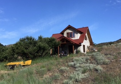
77 miles today in over 100 degree heat. During our rodeo adventure last night we met Sarah and Walter who recommended an alternate route to the East that (1) avoided a lot of the intense climbing that awaited us and (2) took us through some very pretty high mountain pastures on very quiet roads. Competing with trucks and RVs on the highways (two lane state roads) is nerve racking and the noise annoying so the opportunity to get where we were going in more relaxed conditions was very appealing. Unfortunately, their route out of Tonasket started with 12 miles of Granny gear climbing so it wasn’t all a cakewalk. The reward was breakfast at Sarah and Walter’s beautiful mountain home – 160 acres on top of a mountain that they handcrafted (Walter was a doctor and Sarah a Physician’s Assistant so it’s not like they had a lot of free time to build this house!) themselves while also raising their family. We took a long morning break and reluctantly got back on the road.

Breakfast view
The route was exactly as billed and after a pretty challenging climb, we began following another river so we had a fair amount of downhill for the rest of the day (with one painful exception). We stopped by a mountain lake and jumped in fully clothed just to cool off. We eventually joined the Kettle River road that follows that river downward. It actually flows north for a bit into Canada and will reemerge into the US on our trek tomorrow.


We had our passports but had to wait while they vetted us since we hadn’t been into Canada in over 22 years! But we made it in and are staying the night in a real hotel (no tent tonight).
Tomorrow will be a relatively short 88 km (we are in Canada remember) to a bike hostel in Colville, Washington, and we will rejoin our planned route and maps.
 les – just like the small town parades I grew up with in Missouri. They closed off Main Street and the sidewalks were lined with people … And here we thought they were there to welcome us to Tonasket!!
 The rain stopped early so we broke camp and headed out. The road starts up immediately eventually leading us from 600′ to just over 5000, the first test of our training! Up and up we slogged through waterfall vistas and valley views. There were occasional rewards of small downhill sections but the reality of the climb was a hard truth. We knew we had 40 miles to the top of Washington Pass but at the rate we (translate as “Charles”) was climbing, necessitating multiple stops for water and rest, the clock edged toward 6 hours in the saddle with no peak in view. Finally I succumbed to the effort and had to walk my bike. We agreed that Maja would go ahead and see accurately how many more miles we had while I sat disconsolate by the roadside! Poor, poor pitiful me. Almost immediately a very nice German couple stopped to ask if everything were fine … Of course not everything was fine and they took pity on my sapped strength and total lack of water (an early first lesson on this ride – always have more water than I think I will need. We loaded my bike and bags into the back of their pick up and Yvonne (of Andreas and Yvonne) offered me several bottles of water. We caught up with Maja and made the plan that I would be dropped off at Washington Pass and rejoin Maja on the road. Andreas and Yvonne dropped me off with more water and I was able to eat, drink and even cat nap for the interval it took Maja to catch up. When she arrived I was re-energized and we headed down, down, down to the valley and, eventually, Twisp. So, my confession is that of the 4273 miles of our journey I did indeed cheat for 4 miles. There, the truth is out.
